Road trip report: spring break at Grand Canyon
For spring break this year, I drove to the Grand Canyon and back with two sixteen-year-old girls (which meant that I did all of the driving). What was I thinking? I was thinking it might be fun. Well, it turns out I was right. I only thought about killing them once or twice; the rest of the time, we were all too busy taking pictures and laughing at each others' lame jokes. The photo highlights (and all of the hundreds of other pictures we took) can be found at my Flickr site.
Our traveling roadshow:


Day 1, Tuesday: Boulder, CO, to Blanding, UT (440 miles): via I-70 and US-191
We hit the road with a box full of canned goods (ravioli, green beans, corn, peaches, pineapple, etc.), plenty of bottled water, a huge music selection (ran the gamut from Kanye West to Madonna to Paul Oakenfold to AC/DC to the Backstreet Boys), and other assorted supplies (especially pretzels).
The first day was the biggest, mileage-wise; we hoofed it all the way out to Utah and then a good ways south, with room for sightseeing stops on the way. We stopped in Glenwood Canyon for a lovely picnic lunch of cold canned ravioli and green beans.
 At a scenic rest area off I-70 in Utah, we took another break, took lots more pictures, and my gravity-defying little sister topped out on a picnic shelter and later somersaulted over a concrete retaining wall. (Actually, she says, she was attempting to vault it at a run, but her foot slipped, and she recovered by throwing her shoulder down and going into a roll. I wasn't paying very close attention, so from my perspective it looked cooler than that sounds.)
 Farther down the road, just north of Moab, we drove through Arches National Park, which was gorgeous. That night, somewhere out on the open highway north of our destination, we stopped on the side of the road to look at the stars and debated over what was or wasn't the Big Dipper or Little Dipper.
Day 1 photos:
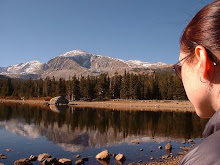
Hitting the road
Eastern Utah
Arches National Park
Day 2, Wednesday: Blanding, UT, to Flagstaff, AZ (262 miles): via UT-95, UT-261, US-163, US-160, and US-89
 We headed west from Blanding to Natural Bridges National Monument. The drive there was beautiful: blue sky, bright sun, rolling hills, towering roadcuts, surprising vistas. The park itself was chock full of picturesque sandstone. We drove the nine-mile loop road, stopped to look and take pictures at every overlook, did some meandering on foot.
Then we headed south for the Arizona border. We knew that we were coming up to a small section of road called Moki Dugway; the park ranger at Natural Bridges said it was a series of switchbacks, descending more than 1000 feet over 3 miles of road surface. Then we came to a pull-off, beyond which the road disappeared over a rise.
 We stopped and walked out to the edge of a sandstone overlook, where I had a monumental "whooooaaaaaaa" moment as the view opened up in front of us. Far below, the highway zigzagged off into the distance across the wide country.
  Moki Dugway, as we discovered when we finally got back in the car and continued down the road, is a narrow, side-winding gravel lane that twists back and back on itself to eke down the side of Cedar Mesa. I drove slowly, enjoying the view, and the girls screamed like it was an amusement park ride around every hairpin curve.
  A little further down the highway, just north of Mexican Hat, Utah, we did some off-roading near Mexican Hat Rock. I was feeling adventurous, the girls were yelling encouragement in my ear, and I went for some of the more exciting tracks. My Subaru Forester handled it all with aplomb; I love my car.
 North of the Utah-Arizona border, US-163 crosses Monument Pass; from a distance, this view struck me as particularly iconic of the great American Southwest.
  Late in the afternoon we drove into Sunset Crater National Monument. It was pretty, but not terribly exciting or spectacular. We had fun clambering through a lava field.
Dinner was in Flagstaff, at a restaurant called Dara Thai that served up delicious and spicy Thai cuisine. Highly recommended!
Day 2 photos:
Southern Utah 1
Natural Bridges National Monument
Moki Dugway
Southern Utah 2
Sunset Crater National Monument
Day 3, Thursday: Flagstaff, AZ, to Kayenta, AZ (230 miles): via US-180, AZ-64, and US-160
Once again, we were blessed with warm, sunny weather.
 We cut northwest from Flagstaff through the mountains, which was a pretty drive, and then continued northward to Grand Canyon National Park.
  We visited Mather Point and Yavapai Point, then did a picnic lunch in the parking lot at the park headquarters. From there we left the car for the shuttle buses, and rode up to Hermit's Rest, with a few stops at overlooks along the way.
  We provided our own additional entertainment by engaging in bizarre arguments (how to best conduct and cover up a mob hit) and pointless ruminations ("if my leg muscles could speak, what would they say?"), as usual, at a volume certain to be overheard by other tourists.
  Returning to the car, we drove eastward along Desert View Drive on our way out of the park, with plenty more scenic overlooks and lots of photos along the way. We made one more stop outside the park, at the Little Colorado Gorge, where we hiked in a little ways from the road and went venturing off the beaten path.
In Kayenta, the hotel desk clerk's dinner recommendation was a small local place called the Blue Coffee Pot. There, we discovered a nice family atmosphere and a down-home-style menu that featured Navajo dishes and other southwestern fare.
Day 3 photos:
Grand Canyon 1
Grand Canyon 2
Days 4-6, Friday-Sunday: Kayenta, AZ, to Gunnison, CO (317 miles), and Gunnison to Boulder (212 miles): via US-160, US-491, CO-145, CO-62, US-550, US-50, and US-285
On Friday we headed for familiar territory. We pulled off the road at Four Corners, intending to stop and take a couple of pictures, but they wanted to charge us $3 admission per person, so we got right back on the road and kept going.
 Lunch was another canned picnic, parked roadside amidst the snowbanks, somewhere in the mountains of southwest Colorado. Over the course of the afternoon we played in the snow, complained at other drivers riding their brakes downhill from the mountain passes, and ate lots of pretzels.
  Towards evening, we made a little detour off US-50 west of Gunnison, up a little dirt track called Alpine Plateau Road No. 867. Thanks to the tire tracks worn into the mud and snowpack, and the hefty snowbanks to either side of the road, I had fun rumbling up and down the hills and sliding around turns. (No sarcasm, either -- I love my car!)
Friday night my parents rolled into Gunnison, a couple of hours after we did; on Saturday we went to the local climbing competition, which my little sister competed in and my dad helped run. We also hung out some with friends from the Colorado-New Mexico region who were in town for the same competition.
Sunday we drove home.

 We pulled off at Kenosha Pass on US-285, and went hiking a little ways into the woods up another mud road. Then, while my parents wandered around the parking area with the dog, I took the girls in the Subaru for a spin up the same mud road. My car came back muddy;
  I was duly pleased. We did lunch at Coney Island, a hot-dog-shaped hot dog stand tucked away among the evergreens just off US-285 east of Bailey, Colorado.
Days 4-6 photos:
Driving home
Statistics:
1461 highway miles
742 photos/videos
4 states (US-160 actually cuts through New Mexico for about a mile)
4 national parks/monuments
--
Labels: everyday, food, travel
posted by the alygator @ 1:47 PM
![]()
![]()

0 Comments:
Post a Comment
Subscribe to Post Comments [Atom]
<< Home